
Format
DIGITAL - Images - JPEG
119 record(s)
Type of resources
Topics
Keywords
Contact for the resource
Provided by
Formats
Update frequencies
Status
draft
-
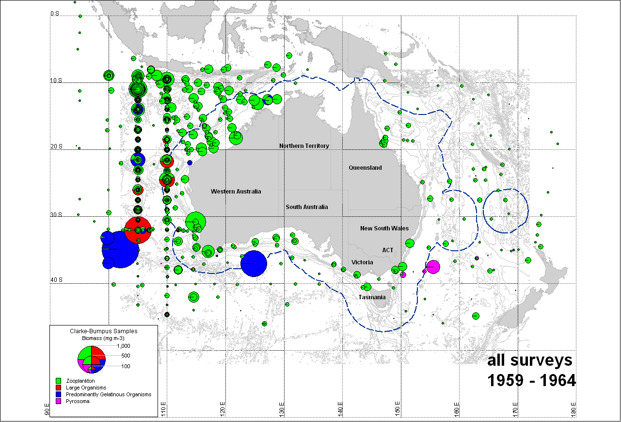
Map of zooplankton biomass in Australian waters. Data collected from oceanographic surveys conducted between 1959 and 1964 onboard the vessels "Gascoyne" and "Diamantina" using a Clarke-Bumpus Oblique Haul, with zooplankton biomass expressed in milligrams per cubic metre. These maps have been produced by CSIRO for the National Oceans Office, as part of an ongoing commitment to natural resource planning and management through the 'National Marine Bioregionalisation' project.
-
Summary Although ecosystem structure and function can be influenced by both bottom up (primary productivity) and top-down (predation) processes (ref), top-down processes (predation) have been demonstrated to account for over 70% of the variation in the some temperate kelp communities (Halpern et al in press). Removal of key predators such as fish and lobsters, has been shown to have the potential to result in trophic cascade effects in which grazers may take over the system, producing massive changes to ecosystem structure. (Babcock et al 1999, Shears et al 2003, Steneck et al 2004). Locally, it has been suggested that predation by western rocklobster Panuluris cygnus may be particularly important in the structuring of local ecosystems. Abundances of P.cygnus have been shown to be strongly negatively correlated with the abundance of large (>2cm) trochid gastropods (Edgar 1990) and adult P.cygnus are known to feed readily on a wide range of locally abundant crustaceans and molluscs (James and Tong 1997, James et al 2001, Power et al 2005). Despite this, understanding about the linkages between lobster predation and local macroinvertebrates populations is still currently very limited. Here we contrast differences in the rates of predation on locally abundant blue mussels Mytilus edulis (Lamarck 1819), using fished and unfished areas as the principal source of contrast. Methods Predation rates on mussels, Mytilus eduli, were measured by adapting predator exclusion methods first described in Edgar 1990. To test the hypothesis that large predators, including P.cygnus, may be controlling abundances of molluscs, caged and uncaged mussels were deployed inside and outside fished reserves at Marmion, Rottnest Island and Jurien Bay. At each of the three locations, 12 similar sized mussels (70mm total length) were attached to a series of 8 plastic mesh grids, with 4 of the grids being fully enclosed to prevent predator access and 4 of the grids remaining open to allow predator access. (Fig. 1) 8 grids were attached to concrete blocks using cable tiestm and blocks deployed in approximately 4m water depth on seagrass substrate immediately adjacent high relief limestone reef. At Marmion and Jurien Bay, 3 blocks containing attached mussels were deployed outside reserves and 2 blocks with mussels were deployed inside reserves. At Rottnest Island 3 blocks were deployed both inside and outside of reserves. After a deployment period of seven days all grids were retrieved and the mussels on each plastic grid recorded as either alive, dead or missing
-

Pilbara Marine Conservation Partnership (PMCP) coral reef survey of benthic cover, between northern Ningaloo and the Dampier Archipelago. The data include: * Benthic Photographs * Digital still images of benthos taken along transects * Benthic cover database * Cover (%) of benthic life forms on 25m transects, derived from point intercept data taken from transect images. ---- The Pilbara Marine Conservation Partnership (PMCP) was an initiative designed to enhance the net conservation benefits of the globally-significant coral reef ecosystems of the Pilbara (Western Australia) by providing an assessment of the condition and trajectory of key ecological values. These assessments were designed to inform and complement existing governance and management arrangements and the PMCP is intended to provide ongoing advice and assessment for conservation efforts in the region, providing lasting benefits. The PMCP concept is based on three core ecological components, namely: Coral Reef Health - concentrating mainly on habitat forming primary producers. Fish and Sharks - their community structure, interactions and impacts on lower trophic levels. Environmental Pressures - physical and anthropogenic factors that influence the condition of reefs and associated biota.
-
This record describes the seabed image data (digitised 35 mm slide still camera images) collected during the NORFANZ voyage on the Norfolk Ridge and Lord Howe Rise in the Tasman Sea between Australia and New Zealand, in May-June 2003. Fourteen seamount and slope sites were sampled, 10 on the Norfolk Ridge and 4 on the Lord Howe Rise. The camera was deployed using two systems: (1) a headline camera unit deployed with the orange roughy net, and (2) a vertical-drop camera system. The headline camera system yielded usable photographs from 14 operations at 6 sites on the Norfolk Ridge and 1 operation at 1 site on the Lord Howe Rise where the camera frame got heavily damaged. The drop camera system was used on 7 occasions: 5 operations at 4 sites on the Norfolk Ridge and 2 operations at 2 sites on the Lord Howe Rise. The dataset contains 2141 images of the seabed.
-
Scanned copies of the Bureau of Meteorology Operational Synoptic Charts covering Australia. The charts are Mean Sea Level (MSL) charts with irregular upper air charts, this collection is on 3 CD's - for the months (April-October) between 1956 and 1959 - for the months (April-October) between 1960 and 1969 - random selection between 1956 and 1959.
-
Maps showing quarterly means of wind curl on Australia's oceans from interpreted basedata supplied by the National Centers for Environmental Prediction (NCEP) Re-analysis Project, 1976 to 1998 inclusive. These maps have been produced by CSIRO for the National Oceans Office, as part of an ongoing commitment to natural resource planning and management through the 'National Marine Bioregionalisation' project.
-

Dive surveys were conducted in 2015 and 2016 to establish a baseline and monitor the status of the critically endangered spotted handfish (Brachionichthys hirsutus) population. This dataset contains track records of variable length, GPS tracked underwater visual census transects conducted within 11 sites across the Derwent Estuary (n=9) and D'Entrecasteaux Channel (n=2). Records illustrated search effort (transect length, swathed area) and total fish sighted along each transect. Data were also presented in a standardised unit, with density estimates (fish per hectare [Ha]) extrapolated for each transect. In addition, this dataset also included information for each sighting of individual fish. This dataset contains size measurement (total length) and location (depth, latitude, longitude) records for each sighted fish.
-
The CSIRO O&A Optimized Voyage Tracks displayed in the WMS associated with this record are derived from underway GPS data collected since 1986 by Australia's Marine National Facility during research voyages. For most of these voyages, five minute underway digital data is available. The underway data set typically includes GPS location, Sea Surface Salinity and temperature, and Meteorology Station data. Later voyages also recorded digital echo sounder data. Individual metadata records have been created for each research voyage. The data is held in the CSIRO O&A Data Warehouse, which currently holds underway GPS data for more than 200 voyages.
-
Incidental photographs of field activities were taken by field staff during research voyage SS 03/2005 on the RV Southern Surveyor. Subjects include the research vessel, prawn trawls, epibenthic sleds, CTD casts, box cores and life on the ship.
-
This biological overview for the Southern Surveyor voyage SS 07/2005. The voyage took place off the Western Australian Coast during July August 2005. This dataset has been partly processed and has not yet been archived within the CSIRO Marine and Atmospheric Research Data Centre in Hobart. Additional information regarding this dataset is contained in the cruise report for this voyage and/or the data processing report. On this cruise pigments and chlorophyll a were collected by Neale Johnston and later processed at CMAR, Hobart by Pru Bonham.